The city, which for many was a dream, has disappeared. It became a ghost.

Image created by Sentinel Hub
Russia continues to methodically destroy the port city in southern Ukraine. Large-scale destruction of residential buildings is clearly visible on satellite images.

Image created by Sentinel Hub, Maxar
Russia continues to methodically destroy the city. Chernigiv on satellite images.

Image created by Sentinel Hub, Maxar
A very famous place in Ukraine, which for many is the final destination. Satellite images show another cluster of enemy forces at this location.

Image created by Maxar
Unsuccessful Russian bridge

Image created by Maxar
A unique Kinburn Spit Reserve is being destroyed in the temporarily occupied Kherson region. Now there are fires in the Black Sea Biosphere Reserve of the National Academy of Sciences of Ukraine.
May.09. Heroiske, Ukraine. Black Sea Biosphere Reserve of NAS of Ukraine

📸 Sentinel-2 🛰️ image
The story of unsuccessful attempts by Russian troops to gain a foothold on Snake Island and a successful hunt for them by Ukrainian combat drones.

📸 Maxar 🛰️ image
Ukraine's armed forces withdraw only when there is nothing more to defend. The Russians are destroying everything they can get their hands on.

Image created by Maxar
This is a map of the war of aggression between Russia and Belarus against Ukraine! Stop Putin!

Planes that bomb Ukrainian cities are recorded on satellite images.

Fires and explosions at the occupied nuclear power plant.

Run

Камні з неба

Long defense trenches dug by the Wagner group, Donbas. They are seen behind the rows of anti-tank pyramids.


List of sites, channels, etc., where you can find information, photos
Wanna add a link to the list? Open an issue or contact me: Telegram
| name | lang | places | categories | |
|---|---|---|---|---|
| Sentinel-Hub | en | #europe #international | #data #satellite | ------ |
| SentinelHub - Playground | en | #europe #international | #data #satellite | ------ |
| Planet | en | #europe #international | #data #satellite | ------ |
| Axios | en | #US #international | #data | ------ |
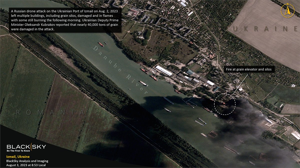
| Blacksky | en | #US #international | #data #satellite | Blacksky |
| Radio Free Europe | en | #US #international | #text | |
| mapconcierge | en | #Japan | #data #satellite | |
| Reuters | en | #international | #text #data | ------------------ |
| Maxar | en | #international | #data | Maxar |
| Nasa | en | #international | #data | |
| EarthExplorer | eu | #EU | #data #satellite | ------------------ |
| LandsatLook | eu | #EU | #data #satellite | ------------------ |
| Mike Eckel | en | #US #international | #data #satellite | Mike Eckel |
| Ukraine Crisis Hub | en | #UA #international | #data | ACLED |